Showing posts with label Omaha Trail Maps. Show all posts

Tuesday, May 5, 2009

Bus Workout

This afternoon I took the MAT Route 95 Bellevue Express from downtown Omaha to Old Town Bellevue. The idea was to log a bus ride for the YP Bus Challenge, but not wimp out on a nice workout in this great spring weather. I had been talking with Brady about wanting to step up the cycling activity a bit, and decided to put my legs where my mouth is.

Before leaving work, I looked at the various wind speed and directional indicators that I use (flags on the First National building) to plan a route. The fierce and incessant south wind told me that I should try to ride south to north, if I could. I've taken a bus to ride home on the Keystone from the north before, so I was up for a change.

The 95 was very different from typical city routes. Once it drops off a lot of folks at the No Frills Park and Ride on Fort Crook Road, it turns uphill to meet up with Bellevue Boulevard and then continues south to Old Town Bellevue. The boulevard is a very scenic route running through the prettiest rolling hills in Bellevue. This route would get you close to the trails at Jewell Park, by the way.

Once in Old Town, I rode up to a convenience store for some Gatorade and Nutter Butters cookies. I didn't have a water bottle with me, so I knew I'd need some liquid refreshment. Then I headed down to Hayworth Park where the Keystone Trail/Bellevue Loop terminates.


View Keystone Trail in a larger map

I hunkered down and rode, slowly, against the wind for the first five miles. I kept a low gear and high cadence, to avoid stressing the still-tender knee. Finally the trail turned west, and then northwest, and I got to enjoy 15 miles of sweet tailwind all the way to Grover Street. I didn't have a speedometer or GPS running, but I think I was cruising 18-20 MPH without straining too hard. I know I got a decent workout, though, as there was quite a bit of sweat involved (most of it on my glasses; how can I stop that?).

My morning ride to the 76th and Cass MAT transit center was five miles, and my ride home from Bellevue was 22 miles. After getting minimal miles over the past two weeks of the YP Bus Challenge, I was very happy with my 27 mile commute today.

Now if I could only do a 27 mile commute every day I might drop a few more pounds and get some faster legs.

Sunday, February 8, 2009

Bike Signage Goes Up On The Turner Boulevard Trail

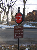
The City of Omaha erected new signage along the Turner Boulevard Trail around January 28, 2009. If I remember correctly, that's the day I didn't see the new bike path stop signs in the morning, but did see them in the afternoon. It's remarkable to me that the City erected the signs with a quite a bit of snow and ice still on the streets. I guess a work schedule is a work schedule, and deadlines must be met.

These decorative stop signs are appropriate for the historic neighborhoods through which the trail runs. The stop signs are about half the size of a regular stop sign, and serve to remind cyclists to stop where the path crosses a street.

In my opinion, they also help to legitimize bicycle traffic to citizens who may not otherwise understand cycling issues by visually reminding motorists to expect the cycling traffic. I'd like to see some "bike crossing" signs around here as well.

At the intersection of 36th Street and Pacific stands a stop sign with some information about how to connect with the Field Club Trail. It reads:

TO FIELD CLUB TRAIL
BICYCLES [arrow pointing West]
(FOLLOW PACIFIC ST.)

PEDESTRIANS [arrow pointing South]
(FOLLOW 36th ST TO WOOLWORTH AVE.)
I would imagine that a similar sign will show up on the Field Club Trail at Pacific Street directing users up the hill toward 36th Street.

Originally, I thought that the Turner Boulevard Trail would connect directly with the Field Club Trail, but the placement and wording of this sign makes me think not.

These kinds of in-town, urban trails connecting neighborhoods together, and to the greater trail system go a long way to show the City's commitment to promoting cycling as part of the overall transportation plan.

More Turner Boulevard Trail information:

Saturday, January 10, 2009

I'm Not Supposed To Be Here

Like Deteriorata, the National Lampoon spoof of the Desiderata poem, apparently I have no right to be here, or at least on the Field Club Trail. (See both poems here)

Friday morning I rode the Field Club Trail to work from Vinton to Pacific. With temperatures in the mid to upper 20s, the pre-dawn ride was very pleasant. It was very dark in some places, and I even came close to oncoming joggers a couple of times, despite having both a solid halogen beam and a blinky LED on my handlebars, I didn't see them. I am sure they saw me, so I wasn't worried about collisions.

To each person I overtook or passed in the opposite direction I gave my cheery, "Good morning!" Most either waved or greeted me back.

As I was approaching Pacific Street, I came upon a man walking a tiny dog. "Good morning," I said in my genuine "it's a great day to be alive" voice. He must have thought I said something else, as his response was a loud:

"You're not supposed to be on here, rapscallion!"

Note, that the word "rapscallion" was not his word of choice. I was called an important part of both the male and female anatomy; a part of significance to cyclists, in that if this particular body part is sore, one cannot enjoy a day in the saddle.

Well, how do I react to this? I just chuckled to myself. The thought that I, while cycling, was not permitted on the Field Club Trail, was preposterous.

I have a fatal flaw. In situations of public rudeness, I always try to imagine why someone would act that way. I always speculate and try to rationalize the behavior. The best I could come up here was:

  1. The dog walker thought I was a motorcycle, electric scooter, or some other sort of motorized vehicle due to my bright headlights. I don't ride particularly fast, but perhaps he saw me coming for a half-mile or more, with anger building up by the time I finally passed him. Despite my friendly greeting, he had already worked out what he was going to say to me.

  2. He thought there were some sort of hours of operation that disallowed cyclists on the trail at certain times, perhaps excluding bikes in the pre-dawn hours. I tried to find an online resource outlining trail hours of operation, but could not. I do know that some city parks have operating hours posted prohibiting use between, for example, midnight to 5am. I think these are posted to outlaw overnight parking.

  3. He's loony.
I've written before about how nice gestures overwhelmingly outweigh mean ones. Before the silly smile could leave my face, I came to the intersection of Field Club and Pacific, getting ready to turn right and head up the crazy hill toward the Turner Boulevard Trail. A car heading west on Pacific preparing to cross the trail stopped for me, despite having the right of way. I motioned for the car to come on through, since, you may know, the crossing there is not friendly for bikes with all of the gravel and tire-eating grates spanning the road. I was turning right, anyway and not proceeding along the trail, as the driver may have thought.

The gesture was appreciated, though, and helped to assure me that there are probably more friendly drivers than crazy dog walkers.

Sunday, October 5, 2008

Map of the Keystone Trail


View Larger Map

Certainly all walkers, runners, and cyclists in and around Omaha know the Keystone Trail. A map of it on this blog is certainly not news. However, I'm a map geek and felt compelled to draft my own map with notations on where to get water and use the restroom. It's part of my plan to draw individual Google maps for all trails around Omaha as an online resource for myself and anyone else who cares to use it.

Running about 25 miles roughly north/south across the city, the Keystone Trail is one of the core bile trails in the city. With connections to the West Papio Tail, the Big Papio Trail, and eventually to the Field Club Trail, and running through many neighborhoods and the commercially dense 72nd and Dodge area, chances are high you can use the Keystone to get somewhere on your bike.

I've ridden from my house in central Omaha to the north end at Democracy Park several times (16 mile round trip), and finally this weekend I had the opportunity to ride from my house to the south end at Hayworth Park (42 mile round trip). Having seen the entire trail, I thought it was a good time to map it.

This sculpture shown below stands at the trail head at Hayworth Park in Bellevue. This sculpture is, in my opinion a monument to the prairie settlers' use of the ever present Nebraska wind, and also an illustration to what you can do with a sack full of zip ties. The inverted bike swivels to stay pointed into the wind. I'm sure the wheel spins 90% of the time.

I didn't see any Treks or Cannondales in the sculpture. Just a bunch of old department store bikes. I also didn't see a plaque of dedication or attribution. Does anyone know more about this?

Friday, October 3, 2008

Map of the Pedestrian Bridge


View Larger Map

I surveyed the Bob Kerrey Pedestrian bridge this afternoon using my GPSr. These devices are not terribly accurate for this sort of thing, but by doing it twice and eyeball-averaging the two routes, I think it's probably not too far off.

I also updated the Omaha Bikeway map to include the bridge data.

I'll enjoy seeing the aerial/satellite photos show up on Google Maps and see how well or poorly I did. I had no idea that the Nebraska/Iowa border is almost on the eastern shore of the river when crossing the bridge. I had just assumed it was near the middle of the bridge over the water.

Wednesday, October 1, 2008

Updates to the Turner Boulevard Trail

The finishing of the Turner Boulevard Trail is coming along nicely. The grass seed planted along the banks of the trail is growing well, and yesterday I noticed new signage had been posted.

The signs identify the trail at a couple of points, and other signs show upcoming curves and remind users that only non-motorized vehicles are allowed on the trail.

I believe that the only thing that remains is to finish the sidewalk path along the north side of Pacific Street from the Field Club Trail to Turner Boulevard.


View Larger Map

Read my previous blog entry on the Turner Boulevard Trail.

I read in the news that a 100 year old tree near 34th Street and Turner Boulevard had to be removed for safety reasons. I noticed a tree stump today near that intersection, but I'm not sure if it's the same tree. My guess is that we are going to see some landscaping in this half-block area just north of Leavenworth.

Saturday, September 27, 2008

Ralston Trail


View Larger Map

About an hour before sunset I went exploring to see where the Ralston Trail goes. With my GPS receiver on, I was able to make a good map of the trail, where I then imported into Google Maps, cleaned it up a little, and added some labels. Unfortunately, I didn't bring my camera, and I also forgot my camera phone, so I don't have any pictures to share.

Basically the Ralston Trail runs 1.3 miles from 84th and Madison, eastward toward 72nd and U. St. The eastern terminus of the Ralston Trail is about one-half mile from the junction of the Big Papio Trail and the Keystone Trail, making the Ralston Trail potentially an important connection for commuters looking to move east/west across Omaha.

One feature of this trail is a hilly section that runs through the wilderness of Wildewood Park. The leaves were just starting to fall and cover the concrete path, and with the scent of Autumn in the air, the short ride through the park was a welcome change over the normal daily street ride commuting that I do. Another interesting point along the trail is a short tunnel where the trail passes underneath a rail bridge. I don't know why the tunnel was needed, unless engineers felt the old bridge overhead might come crashing down on the trail someday, or perhaps drop debris on the trail.

Ralston has a pretty little downtown commercial district, but unfortunately, this trail won't help you get there. It seems to run, somewhat isolated, along an old rail bed, or at least alongside a creek (a few parts of the trail are more hilly than what I'd expect for an old rail line), but has very little access to meaningful streets. To the south is a creek and to the north are people's back yards or industrial fences. I can't help but wonder if there are future plans for this trail that might make it connect more directly with the Keystone and Big Papio, or possibly continue further out west.

According to the ActivateOmaha bike map, there is a north-south sidepath that connects the eastern terminus with the Big Papio Trail near L St., but I didn't know that while I was out.

The Highgear Bike and Outdoor Store of Omaha is about 1.5 miles to the south near 84th and Brentwood, making that a potential destination for riders on the Keystone/Big Papio trails.

Wednesday, August 27, 2008

Omaha Residents Oppose Bike Trail in Neighborhood


In this story from July 25, 2008 airing on KETV, Omaha residents near Karen Park (near 62nd St. and H St.) oppose the city's plan to connect the Keystone Trail to the Field Club Trail with a wide, multi-use concrete path running along Buckingham Avenue.


View Larger Map

The plan for the first of two phases is to connect with the Keystone Trail on the east side of the Papillion Creek, go north to Buckingham Avenue, then east to 60th Avenue, then south to H Street. The path then runs north along the west side of 60th Street, then does a switchback to join the old Chicago and Northwestern rail bridge to cross 60th. The trail will then follow the old rail line, cross 50th Street using a pedestrian activated stoplight, and then continue to 45th Street near Dayton Street.


Construction for the first phase may begin Summer 2009. The second phase will connect to the existing Field Club Trail near 35th Street and Vinton Street and will begin shortly after the first phase is complete.


Here's a copy of the map shown in the story.


As a homeowner myself, I can understand the hesitation with respect to an enlarged sidewalk and an increase of foot and cycling traffic running along my street, however, I think the fear is really fear of the unknown and the fear of change. One homeowner mentioned that she's seen bottles, trash, and fights by the trail at Karen Park. I've ridden through Karen Park many times, and I certain that this is not the doing of cyclists. Maybe she means some other kinds of "bikers" loitering in the park or the Karen Park Elementary School throwing impromptu parties. In all my years of riding the Keystone, I've never seen cyclists tossing bottles and trash on the path.


In the end, this can only be a positive, progressive thing for Omaha. As a bike commuter, I can tell you that bike routes running east and west are extremely rare. The Keystone East Connector Trail will allow commuters to get from origins out west to in-town destinations like downtown and Midtown Crossing, making Omaha more of a bikeable community supporting sustainable transportation.